Balance of tree & grass cover
The Australian beef industry manages half of Australia’s landmass. Much of the beef it produces is the result of grazing cattle on land that cannot support other food production.
The industry manages the land by balancing tree and grass cover for grazing and environmental benefits.
Overwhelmingly, activities to improve production also improve environmental outcomes, for example through nutrient cycling. The industry recognises in some areas, production and environment must be managed separately. In Australia, well-managed beef production systems are integrated with biodiverse ecosystems.
It remains important for the Australian beef industry to prove its environmental credentials, including how it manages tree and grass cover.
Australia is tackling difficult environmental challenges. As managers of so much land, producers recognise their responsibility to protect and improve the land. The beef industry is aware of the negative impact of some operations, and many in the industry are effective environmental stewards with little recognition. Beef producers hope to continue productively collaborating with those inside and outside the industry to achieve what’s best for the environment, animals and community.
The industry’s strategic plan, Red Meat 2030, aspires for Australian red meat to be recognised “globally as world leaders in agricultural and environmental management and stewardship practices”.
The Australian beef industry has been working closely with key customers, stakeholders and technical experts in this area, including through the Framework process. This includes convening an Expert Working Group to develop the practical, evidence-based measures for this priority. The Framework reported against these measures for the first time in 2019, and has done so again in the 2020 Annual Update.
Caring for the land is becoming more challenging for farming. The climate is becoming more variable and extreme weather events more frequent. The unprecedented bushfires that devastated parts of Australia over the past summer highlight the complexity and importance of managing vegetation and fuel loads in a changing climate.
Industry position
The industry believes well-managed landscapes and livestock production are not mutually exclusive when looking at the whole farm system. In many landscapes, cattle can be grazed across the property. Others require a mosaic style of management, where some areas are protected to preserve the ecological value on the farm, while other areas are used for production.
The industry is committed to:
- Responsibly managing vegetation within the landscapes for the dual benefits of food production and ecosystem services.
- Recognising that all federal and state laws to protect and enhance areas of high conservation value are the minimum compared with best practice.
- Managing landscapes in a manner that is regionally appropriate with consideration to farm planning with an appropriate balance of tree and grass for:
- Grazing livestock.
- Conserving and where possible enhancing biodiversity.
- Focussing on maintaining ground cover to prevent soil run-off into waterways.
- Actively managing re-growth to protect existing pastures and grasslands.
- Actively managing vegetation when required for fire breaks, weed and pest control.
What the data is telling us
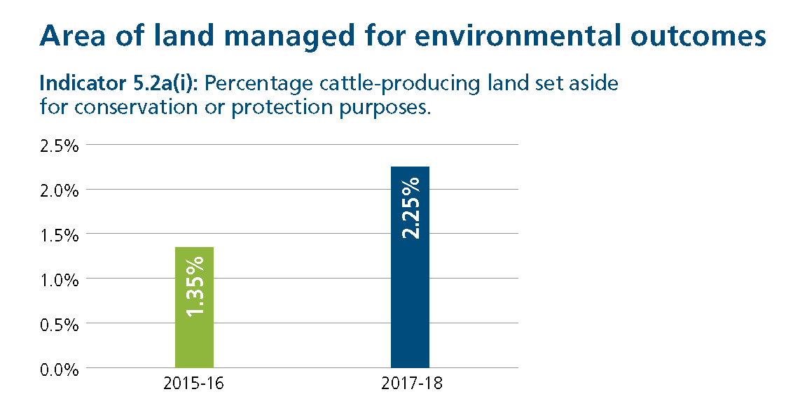
Data for both the indicators have been collected from the Framework’s annual sustainability survey, which is currently the best available data source. Land set aside for conservation or protection has increased to 2.25%, representing 6.4 million hectares of cattle-producing land. This includes reserves, parks, heritage sites and indigenous protected areas.
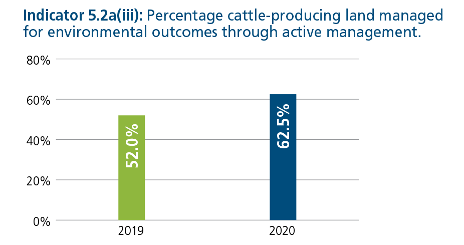
There has been more actively managed land this year. Note that as the data came through a survey, this change could be due to a shift in respondents. Active management activities that contribute to environmental outcomes were developed in partnership with NRM Regions Australia. These activities include weed, pest and erosion control, applied soil treatments, fencing waterways and features that require protection to prevent livestock access, and destocking pastured, bushland or riparian areas.
The Framework is continuing to investigate a methodology to measure indicator 5.2a(ii), the amount of land managed by beef producers for conservation outcomes through formal arrangements.
View a comprehensive regional breakdown of ground cover levels.
Measuring changes in tree and grass cover
In 2019, we embarked on developing a world-leading capability for measuring and monitoring changes in tree and grass cover. Following extensive consultation, key indicators were developed by an independent Expert Working Group. Measurement of these indicators has been implemented through a partnership with Cibo Labs. The history of this work, alongside how this data is measured and collected, can be found here.
Following advice from this Expert Working Group, data looks at both vegetation loss and gain across regions. The Framework aims to report at a national level, and this may mean that reported data can be very misleading if the regional context is not considered. For this reason, the Framework has outlined vegetation trends across the 56 NRM regions here. The Framework is continuing to investigate appropriate ways to report national tree and grass cover changes that also capture regional context.
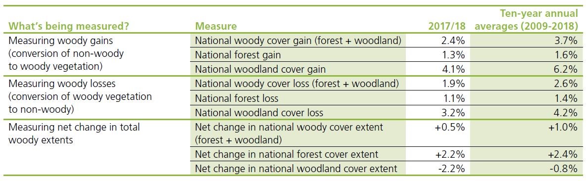
The Framework has distinguished two classes of woody vegetation – woodland and forest. This differentiation aims to address persistent movement between vegetation classes. A loss in forest can be due to clearing or a loss in density to woodland.
National changes in woody vegetation classes
The table below shows the loss and gain of woody cover across the woodland and forest classes.
- Woodland is counted as vegetation with 5-20% canopy cover.
- Forest is counted as vegetation with >20% canopy cover.
A national forest cover gain of 1.3% means that from 2017 to 2018, the conversion of non-woody to forest was responsible for a 1.3% gain in forest extent. Conversely the 1.1% loss means that from 2017 to 2018, 1.1% of the forest extent was converted to non-woody. The net change in extent is shown in the third section of this table.
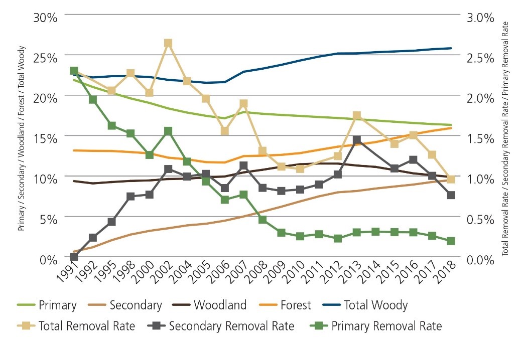
Overall Australia’s grazed agricultural lands are increasing in woody vegetation. Over the last decade we are also seeing a general increase in the density of woodland areas through a transition from woodland to forest. Trends in the primary woody vegetation removal have declined by more than 90% from 1990 levels, and since 2009 the national annual removal rate has been less than 0.3%. These losses include fires and commercial forestry on private land, so overestimate annual losses from grazing enterprises.
National changes in ground cover
The trends in seasonal ground cover and rainfall (Figure 2) are difficult to unpack at the national scale, though there are certainly long-term trends which have an impact on land resource condition. The severe impacts of widespread drought through 2017-2019 saw ground cover levels for around 50% of Australian land fall below 50% ground cover.
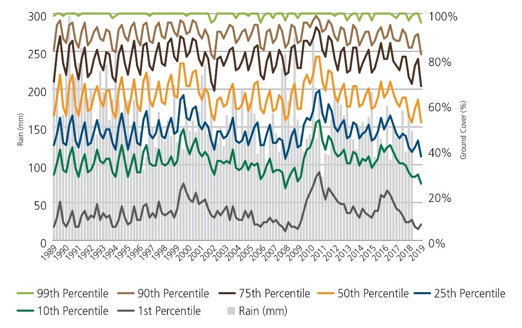
The decline in ground cover levels has been occurring nationally since 2011. National statistics, however, mask much more severe declines in ground cover at regional and property levels where ground cover has been significantly below regional targets in many areas. Regional and local declines in ground cover due to poor seasonal conditions and prolonged drought means producers will need to invest in managing soils and land condition to minimise negative impacts on the environment.
Snapshot of activity
Industry projects to improve how the Australian beef industry cares for the environment, and demonstrate its environmental credentials, include the following.
Verifying sustainable production
Considerable work is being done to develop a way to verify sustainable production. MLA has secured Smart Farm partnership funding from the Australian Government to pilot and roll out an innovative national online sustainability tool which will offer verifiable sustainability credentials for producers who opt in. Five Sustainability Credentials and supporting modules will enable broad-acre graziers to assess their on-farm performance and management:
- Vegetation retention and enhancement
- Grass cover and soil conservation
- Biodiversity stewardship
- Carbon accounting
- Drought resilience.
Participating graziers can have their practices verified against these standards through remote sensing technology. The platform will enable graziers to demonstrate their sustainability and access markets for sustainable beef.
In parallel, MLA has partnered with McDonald’s to pilot a whole-of-value-chain beef sustainability program that could utilise this tool. A pilot of this program is being conducted that will test the online sustainability tool, and test how a whole of value chain program could operate.
NRM Regions Australia
Across Australia there are 49 NRM service providers acting as delivery agents under the National Landcare Program. They focus on:
- Ramsar wetlands
- Threatened species
- World Heritage properties
- Threatened ecological communities
- Conditions of soil, biodiversity, and vegetation
- Agricultural systems adapted to changes in climate and market demands.
Discussions continue to identify opportunities to partner on delivering positive environmental and production outcomes.